
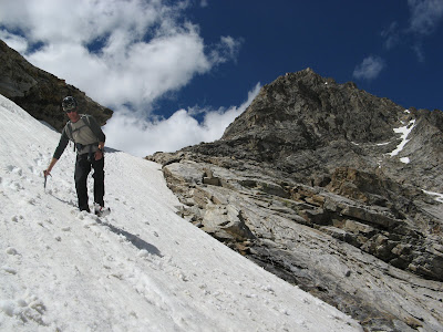
Sky Pilot climbs the obvious sun/shade arete to the summit of 11,280'.
With a day off from guding and neglecting duties around the home, Drew and I headed into Wildhorse Creek to do some climbing on a feature I had only seen on a topo and Google Earth. Since taking the Alpine Course this spring, I have been trying to climb as many alpine routes as possible as well as develop strength with sport climbing. Drew had been into the north face of Brietenbach a few days before with our fellow guide Clark and got turned around by poor rock and a lack of protection. Wanting to do something big and alpine, but not wanting to drive all the way to the East Fork of the Pahsimeroi to get shut down, we settled on Wildhorse.
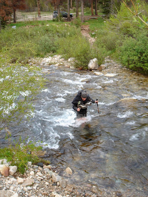
We met in the wee hours and drove into Wildhorse Creek to the Wildhorse Mine. On the drive in we could see what was once the bridge crossing the creek about 100 yards down stream from the mine. There's nothing that will wake you up more than fording icy waters first thing in the morning!
Our intended route climbed above one of the Wildhorse Lakes at 9200'. We made quick time hiking into the upper basin and were in awe of the alpine topography hidden from view of Wildhorse Creek road. We put harnesses and helmets on at the lake, pulled out our axes and booted up a steep snow slope to access the rock. A ledge system cuts through the lower cliff band and brought us to the base of the ridge/arete, where we roped up and began climbing. Our system was a mixture of simul-climbing with Tiblocs and pitching it out when things got steeper. Initially we wrapped around to the right (north) side of the ridge to avoid vertical rock. Then a few short pitches brought us back to the arete, which we climbed for the next 1500' or so to the summit. Like so many other ridge/arete routes in the Pios (Broken Arrow on Mustang Peak, and the North East Ridge of Devils Bedstead West) the climbing was generally easy on good rock with fantastic exposure! The great thing about this route was it's length: basically 2000' feet of technical climbing brings you to the unnamed summit of 11,280'.

The ledge accessing the upper basin and the base of the route.


Gettin' some in alpine boots!


Drew making short work of one of the 5.6 sections high on the route.

Great exposure at 11,000' near the summit!
After some lunch on the summit and hanging out with the Ladybugs, we descended to the southwest into the adjacent basin, below the impressive face of Goat Peak. Fortunately there was still some snow and plunge stepping was much easier than navigating steep scree and cliffs. Once back at treeline we spooked a herd of elk hanging out in the lush alpine meadows getting fat on summer's greenery. We dropped back down into Wildhorse Creek and returned to the mine for another cold creek crossing on sore feet. What a great day in the alpine!


Messaging sore feet with Mustang Peak in the background.

Drew and I decided to name the route Sky Pilot, after the aromatic alpine flower found on ledges and cracks the entire way. We gave the route a grade III for commitment level due to it's length of technical climbing on the ascent. We felt like what we climbed was probably 5.8 based upon a steep but short finger crack pitch I led near the top, but that could easily have been bypassed. There were several short pitches of 5.6 climbing with lots and lots of easy fifth and forth class in between.
Wow!!! Good eye on the route. Anyone would agree, 11,280 is one of the most impressive points in the entire WH basin, its drawn my lens nearly every time I've been back there. it's been a while since I've been in that particular cirque but it seems like the arete starts pretty high on the route. In your photos, it looks like you didn't have much of a problem with pro, did you have to run it out very often? Congratulations on Big stuff!
ReplyDeleteThanks a ton, Wes! It's good to hear from you, especially since you have spent so much time in the WH drainage. You're right, the bottom portion of the route has a steep buttress on the climbers left side and easier terrain on the right. If you look closely at the photo of the route, you'll see a small nob about a 1/4 of the way up the arete. This is where a snow couloir cuts in on the right side and we were able to get on the actual arete and "pilot" it to the top! We climbed several lower pitches including a couple "cruxes" before gaining the artete. For the most part we found good pro on good rock. We definitely ran it out in places but that was more a result of our comfort level on easy terrain rather than a lack of pro. We did rid the route of many teetering blocks, which led us to believe that it had not had any previous ascents, but hard to know really. What is deceptive is the amount of up and down near the summit there is to navigate. I had originally thought it was grade IV, but have since downgraded it to III. Climb it and see what you think!
ReplyDeleteCheers, Marc
Hey Marc, I didn't know you are with the Sawtooth Mountain Guides.
ReplyDeleteCorey-
ReplyDeleteYea, I've been guiding summers with them since 1999 and winter stuff since 2003. I also ski guide with Sun Valley Trekking and have been doing that since 2007.
Cheers, Marc